HISTORIX Vintage 1825 Map of Greenville District South Carolina Poster - 24x32 I
Shipping options
Seller handling time is 2 business days Details
This reflects the seller's handling time and may not include time spent in transit.
If you have questions about shipping, please contact the seller.
FREE via to United States
Return policy
Full refund available for DOAs
Details
- We guarantee our products and offer full refunds or exchange for defective items or items not as-described.
- Buyer must contact us within 30 days after receipt of shipment.
- The item must be received in the same condition as shipped.
- Items must be returned with all original packaging and accessories.
- Items must not be abused, modified or damaged by accident.
- A 20% restocking fee will be charged for returns
- Buyer is responsible for all return shipping and handling fees.
- Restocking and return shipping fees do not apply when item is returned as defective or because incorrect product was delivered.
Payment options
PayPal accepted
PayPal Credit accepted
Venmo accepted
PayPal, MasterCard, Visa, Discover, and American Express accepted
Maestro accepted
Amazon Pay accepted
Nuvei accepted
Item traits
| Category: |
Laminating Machines
|
| Quantity Available: |
8 in stock
|
| Condition: |
New
|
| ASIN: |
B086BFX7XM
|
| Map Type: |
Territory
|
| Bullet Point: |
View details
VINTAGE MAP REPRODUCTION: You’ll love this high quality historic reproduction of 1825 Map of Greenville District South Carolina Poster. Our museum quality maps are archival grade, which means it will look great and last without fading for over 100...
|
| Product Description: |
View details
This property ownership and county map of the Greenville District of South Carolina was produced in 1825 and provides a sense of the rich history of the region. Printed to scale and used as a valuable resource for the merchants and residents of...
|
| Brand: |
HISTORIX
|
| Unspsc Code: |
55101500
|
| Item Type Keyword: |
wall-maps
|
| size: |
24 x 32 in
|
| Item Shape: |
Rectangular
|
| Paper Finish: |
matte
|
| Item Name: |
View details
HISTORIX Vintage 1825 Map of Greenville District South Carolina Poster - 24x32 Inch Greenville County Vintage Map Wall Art - Property Ownership and County Map of Greenville SC District
|
| Product Site Launch Date: |
2020-03-25T02:58:21.090Z
|
| material: |
Paper
|
Listing details
|
Seller policies:
|
View seller policies
|
|
Shipping discount:
|
Seller pays shipping for this item.
|
|
Posted for sale:
|
More than a week ago
|
|
Item number:
|
1736378035
|
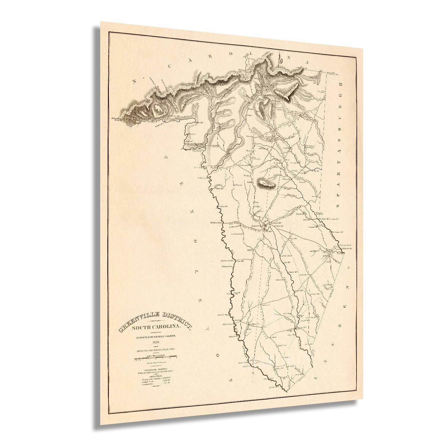
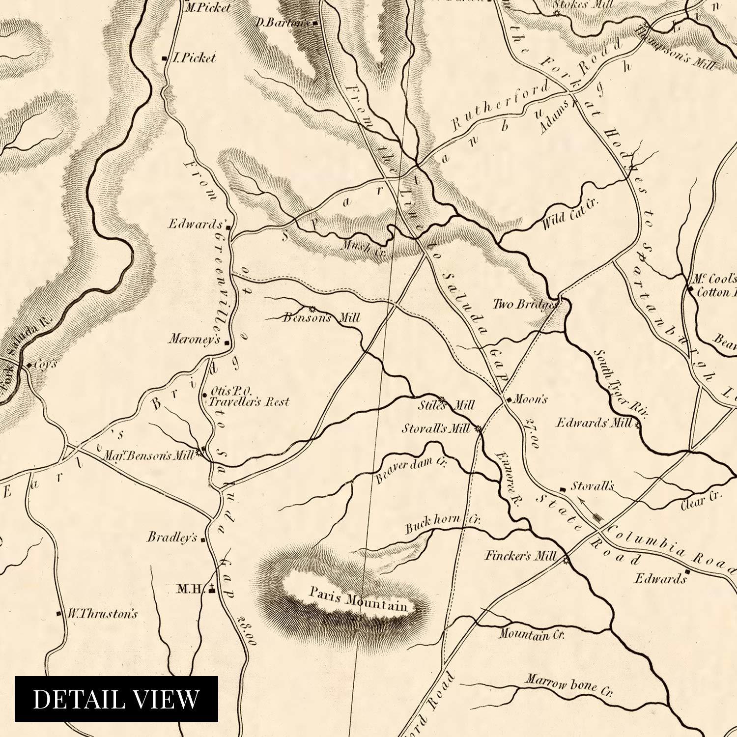
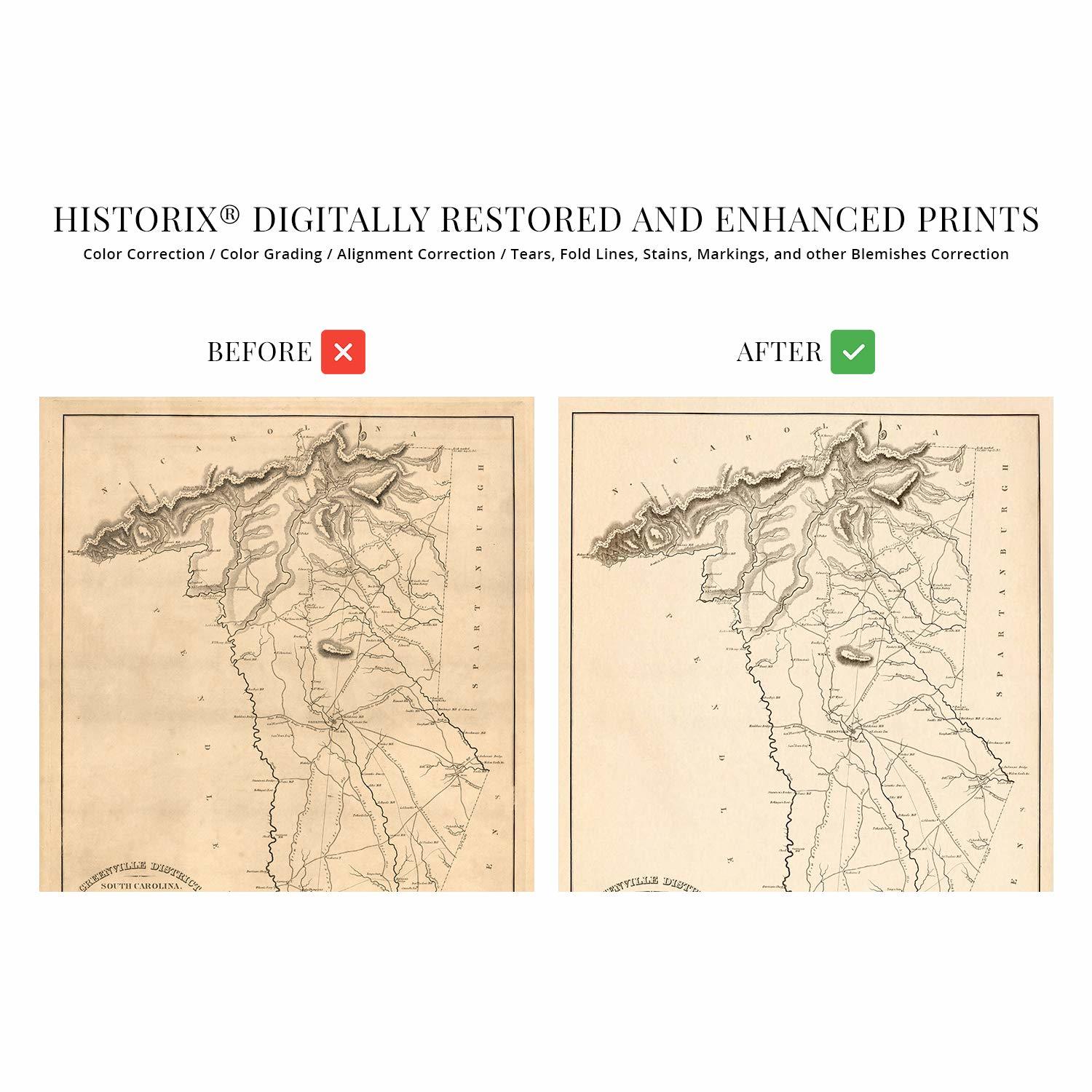
This property ownership and county map of the Greenville District of South Carolina was produced in 1825 and provides a sense of the rich history of the region. Printed to scale and used as a valuable resource for the merchants and residents of the area, this map connects the viewer to the past.
Modern-day Greenville lies atop land initially forbidden to colonists as it was Cherokee hunting land. In 1777 the Treaty of Dewitts Corner and agreement between the Cherokee Nation and American colonists ceded the territory to South Carolina. The County was established in 1786, and locals say the area was named for General Nathanael Greene in honor of his service in the American Revolutionary War. Greene was known as one of George Washingtons most gifted and dependable Generals and brought American victory in the Battles of Guilford Court House, Hobkirks Hill, and Eutaw Springs.
This map pre-dates the annexation of Pleasantburg in 1831 and was printed for Mills Atlas to depict all ownership and property claims. The publisher of the atlas later went on the design the Washington Monument. Mills was also the architect for the original Greenville Courthouse, which was completed in 1823.
The economy at this time relied heavily on cotton and wool milling, and the numerous mills were documented here. The town eventually became home to the Greenville and Columbia Railway, causing the city to grow as a central hub, and allowing residents more access to the rest of the state and country.
Our museum quality giclee print comes printed with archival ink on premium heavyweight matte paper. Shipped in a sturdy cardboard tube your print will arrive ready to be framed. This eye-catching print makes the perfect gift for anyone that loves history and imagery.
Additional Details
------------------------------
Bullet point: VINTAGE MAP REPRODUCTION: You?ll love this high quality historic reproduction of 1825 Map of Greenville District South Carolina Poster. Our museum quality maps are archival grade, which means it will look great and last without fading for over 100 years. Our print to order maps are made in the USA and each map is inspected for quality. This beautiful artwork is a perfect addition to your themed decor. Vintage maps look great in the home, study or office. They make a perfect gift as well.
Product description:
This property ownership and county map of the Greenville District of South Carolina was produced in 1825 and provides a sense of the rich history of the region. Printed to scale and used as a valuable resource for the merchants and residents of the area, this map connects the viewer to the past.
Modern-day Greenville lies atop land initially forbidden to colonists as it was Cherokee hunting land. In 1777 the Treaty of Dewitt?s Corner and agreement between the Cherokee Nation and American colonists ceded the territory to South Carolina. The County was established in 1786, and locals say the area was named for General Nathanael Greene in honor of his service in the American Revolutionary War. Greene was known as one of George Washingtons? most gifted and dependable Generals and brought American victory in the Battles of Guilford Court House, Hobkirk?s Hill, and Eutaw Springs.
This map pre-dates the annexation of Pleasantburg in 1831 and was printed for Mills? Atlas to depict all ownership and property claims. The publisher of the atlas later went on the design the Washington Monument. Mills was also the architect for the original Greenville Courthouse, which was completed in 1823.
The economy at this time relied heavily on cotton and wool milling, and the numerous mills were documented here. The town eventually became home to the Greenville and Columbia Railway, causing the city to grow as a central hub, and allowing residents more access to the rest of the state and country.
Our museum quality giclee print comes printed with archival ink on premium heavyweight matte paper. Shipped in a sturdy cardboard tube your print will arrive ready to be framed. This eye-catching print makes the perfect gift for anyone that loves history and imagery.