HISTORIX Vintage 1926 Texas Map Poster - Vintage Railroad Map of Texas Poster -
Shipping options
Seller handling time is 2 business days Details
This reflects the seller's handling time and may not include time spent in transit.
If you have questions about shipping, please contact the seller.
FREE via to United States
Return policy
Full refund available for DOAs
Details
- We guarantee our products and offer full refunds or exchange for defective items or items not as-described.
- Buyer must contact us within 30 days after receipt of shipment.
- The item must be received in the same condition as shipped.
- Items must be returned with all original packaging and accessories.
- Items must not be abused, modified or damaged by accident.
- A 20% restocking fee will be charged for returns
- Buyer is responsible for all return shipping and handling fees.
- Restocking and return shipping fees do not apply when item is returned as defective or because incorrect product was delivered.
Payment options
PayPal accepted
PayPal Credit accepted
Venmo accepted
PayPal, MasterCard, Visa, Discover, and American Express accepted
Maestro accepted
Amazon Pay accepted
Nuvei accepted
Item traits
| Category: |
Laminating Machines
|
| Quantity Available: |
16 in stock
|
| Condition: |
New
|
| ASIN: |
B0DM4S3NDJ
|
| color: |
Natural
|
| manufacturer: |
HISTORIX
|
| Bullet Point: |
View details
VINTAGE MAP REPRODUCTION: You’ll love this high quality historic reproduction of 1926 Texas Map Poster. Our museum quality prints are archival grade, which means it will look great and last without fading for over 100 years. Our print to order map...
|
| Product Description: |
View details
This railroad map of Texas illustrates a transformative period of growth for the iconic southern region, which borders Mexico and remains one of the most recognizable areas in the United States for its distinct culture and vast size. It feature...
|
| Brand: |
HISTORIX
|
| Item Name: |
View details
HISTORIX Vintage 1926 Texas Map Poster - Vintage Railroad Map of Texas Poster - Old Map of Texas Wall Art - Historic Texas Road Map Print
|
| Item Type Keyword: |
wall-maps
|
| Product Site Launch Date: |
2024-11-06T08:25:24.352Z
|
| sizes: |
View details
16x16 Inch (8 in stock)
24x24 Inch (8 in stock)
|
Listing details
|
Seller policies:
|
View seller policies
|
|
Shipping discount:
|
Seller pays shipping for this item.
|
|
Posted for sale:
|
May 1
|
|
Item number:
|
1743626276
|
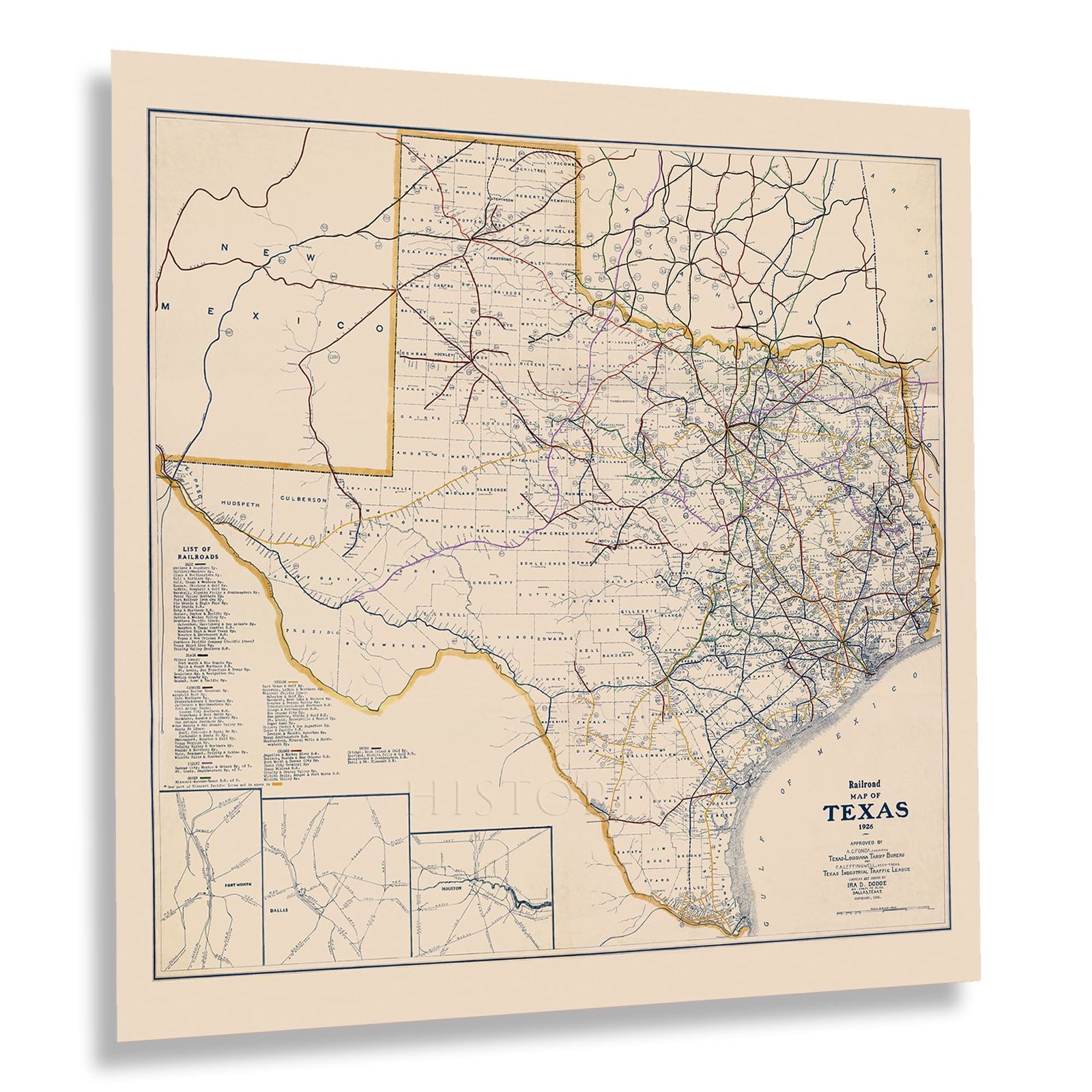
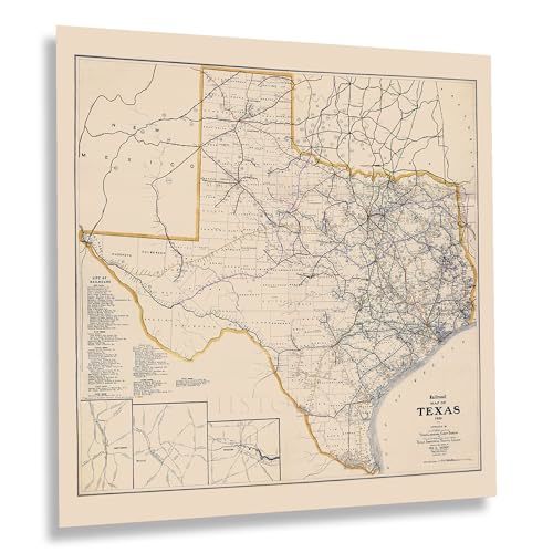
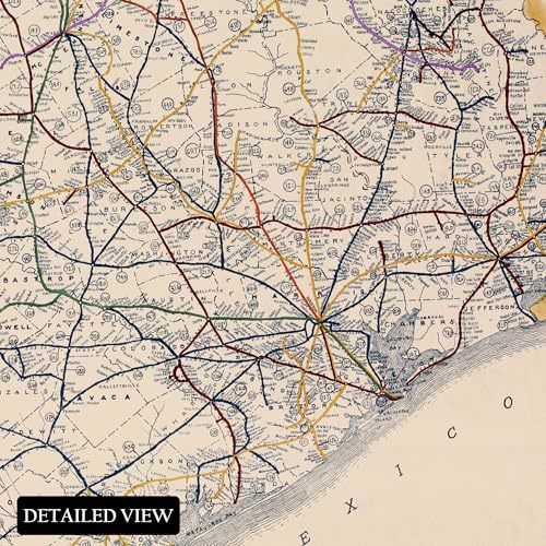
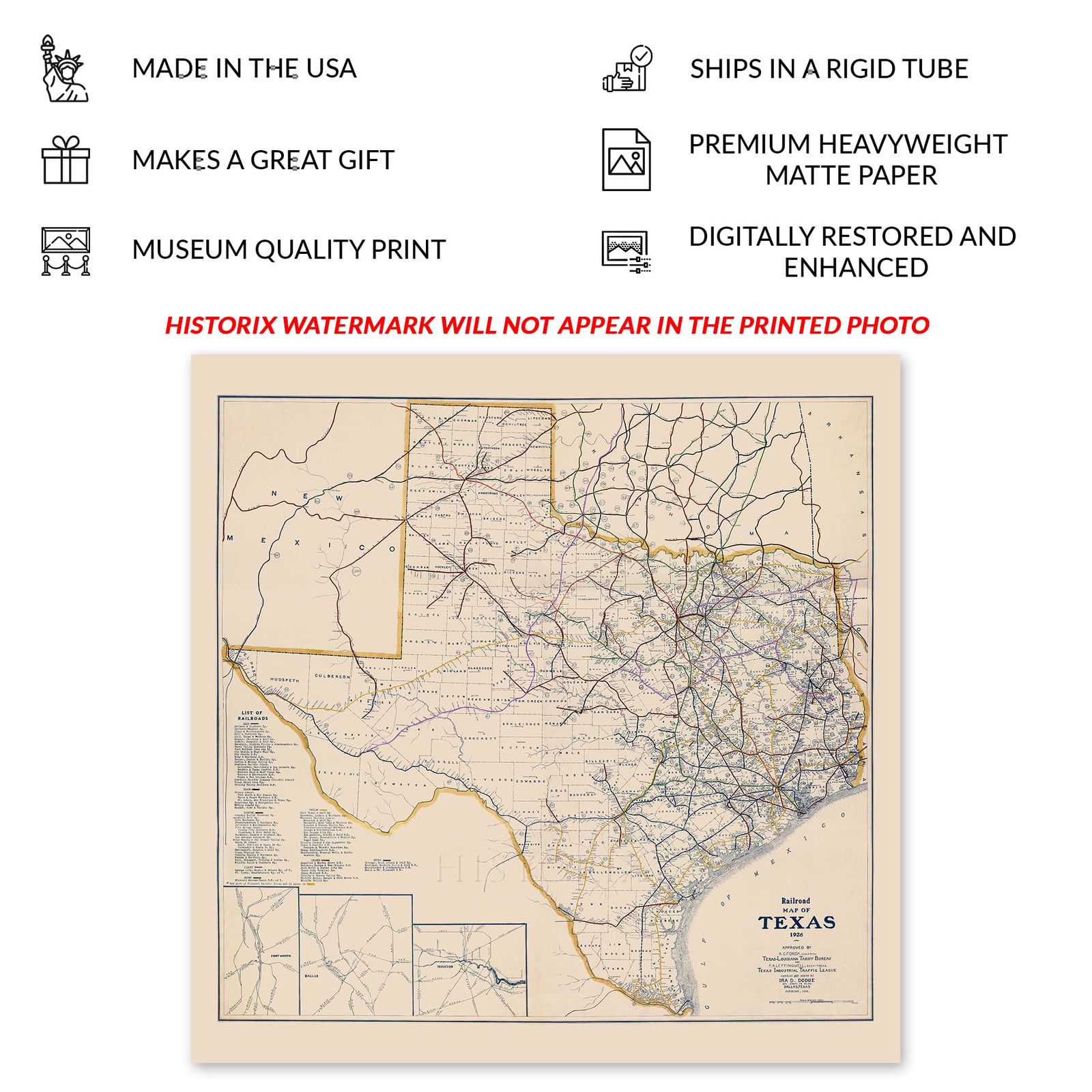
This railroad map of Texas illustrates a transformative period of growth for the iconic southern region, which borders Mexico and remains one of the most recognizable areas in the United States for its distinct culture and vast size. It features numerous climates and landscapes that have contributed to its reputation for cattle ranches, oil drills, and expansive vistas that have been used in countless pieces of imagery depicting the period of westward expansion and cowboy lore of the latter portions of the nineteenth century. By the time of the map's production, Texas had transformed considerably and was experiencing a period of great prosperity with the discovery of vast oil deposits in the western portion of the state, which also spurred the necessity for the construction of railroads to bring crude oil to refineries on the southern coast in cities like Houston and Corpus Christi.
Prior to the discovery of oil in Texas, the primary economic driver was cattle, which was only briefly halted during the Civil War. Texas continued to dominate the cattle market, delivering livestock to markets in cities like Chicago and Kansas City bound for processing and other major markets on the East and West Coasts.
With its large population centers like the greater Dallas metroplex and Houston, Texas is one of the most populous states. This map depicts the state's past and serves as a bridge between the Texas of yesteryear and the bustling state it is today.
Additional Details
------------------------------
Bullet point: VINTAGE MAP REPRODUCTION: You?ll love this high quality historic reproduction of 1926 Texas Map Poster. Our museum quality prints are archival grade, which means it will look great and last without fading for over 100 years. Our print to order maps are made in the USA and each map is inspected for quality. This beautiful artwork is a perfect addition to your themed decor. Vintage maps look great in the home, study or office. They make a perfect gift as well.
Product description:
This railroad map of Texas illustrates a transformative period of growth for the iconic southern region, which borders Mexico and remains one of the most recognizable areas in the United States for its distinct culture and vast size. It features numerous climates and landscapes that have contributed to its reputation for cattle ranches, oil drills, and expansive vistas that have been used in countless pieces of imagery depicting the period of westward expansion and cowboy lore of the latter portions of the nineteenth century. By the time of the map's production, Texas had transformed considerably and was experiencing a period of great prosperity with the discovery of vast oil deposits in the western portion of the state, which also spurred the necessity for the construction of railroads to bring crude oil to refineries on the southern coast in cities like Houston and Corpus Christi.
Prior to the discovery of oil in Texas, the primary economic driver was cattle, which was only briefly halted during the Civil War. Texas continued to dominate the cattle market, delivering livestock to markets in cities like Chicago and Kansas City bound for processing and other major markets on the East and West Coasts.
With its large population centers like the greater Dallas metroplex and Houston, Texas is one of the most populous states. This map depicts the state's past and serves as a bridge between the Texas of yesteryear and the bustling state it is today.